Documentaries it seems are made to create an impact on its audience, and I have viewed a fair few of them. But seldom has any galvanised me into action like the one on Roopkund aired on National Geographic, which sought an explanation for the skeletal remains found in the valley at 5,029 meters (16500 feet) elevation. Roopkund, the Mystery of the Skeletal Lake, Riddles of the Dead, it sounded just like the Famous Five titles I was wont to read in my school days. Inquiries into trek groups all across Pune ended in blind alleys; no one had carved their tracks across this eerie route.
Its strange how when you are thinking of something hard enough, coincidences seem to channel you there. A mail from a Bangalore trekking outfit landed in my inbox, with the welcome news of a trek being organised to Roopkund in September 2008. Excited, I gathered up my savings, dug deeper into the proposed route, made my payments and waited to follow in the footsteps of all those others who had made their way towards impending doom. I was hoping we would not meet the same ghastly end.
I met the group leader Vishwanath along with Pawan, another fellow trekker, at Paharganj and later together went on to receive the remaining group at the airport. After dinner, eighteen of us enthusiasts boarded the train to Haridwar. After checking into a hotel early next morning, we spent the day getting acquainted with our guide, Ratan Singh Dhanu, as well as the others in the group. Having traveled to Haridwar, we also took in Harki Paudi, the sacred place where Hindus come to wash their sins away in the holy Ganges. Breakfast was followed by a trip to Rishikesh, where we hired all our trek essentials: sleeping bags, tents, utensils.
If we thought we were all ready for what lay ahead, our excitement was held in check by a long journey alongside the gushing Ganges, towards Devprayag, Srinagar, Gauchar, Karnaprayag and finally Gwaldam, our starting point.
Gwaldam is a sleepy little town, on the border of Garhwal & Kumaon hills. Set amidst green woods and apple orchards, it is located at an altitude of 1629 mt. 40 Km from Kausani, Gwaldam offers a fascinating view of Himalayan peaks Nanda Devi (7817 mt), Trishul (7120 mt) and Nanda Ghuti (6309 mt). The morning kicked off with cameras flashing to capture the awe-inspiring beauty of this last inhabitation, before the hostility of the Himalayas further on, discouraged the spread of civilisation.

Trishul and Nanda Gunti Peaks
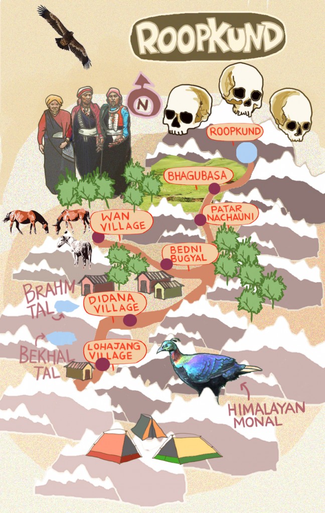
After breakfast we left for Lohajung in Chamoli district, in the interiors of Uttaranchal. Here we had to get off the bus and had to hire jeeps to take us to Wan, first base camp for our trek. Interactions with the families, learning of how travelers had reached them before electricity, and being welcomed into their homes was a great experience. These were the keepers of legend; the lore of Roopkund has passed down across generations, and these people hold the key to unravelling the mysteries of the skeletal remains.
The first morning of our trek began as an ascent from Wan, and then a descent into a valley. This would then lead us into Bedni Bugyal, a climb of a few hours ending in a sheep meadow. Our porters, with a better pace across this terrain, had already made camp as we reached our destination. The lush green meadow was dotted with a variety of blossoms, and I could imagine whiling away my time content at that scenic spot. I chose instead to enjoy the small lake (Vaitarani-Bedini Kund), the rich flora (including Brahma Kamal, Sauseurea Obyallata – a flower of mythological fame and an annual flowering season) and the splendid views of Nanda Gunti, Trishul and Chakhamba peaks for as long as I could.

Reflection photo of Trishul Peak
We also got a weather report from those who had gone before us, a Dutch trekking group who claimed that 3-4 feet of snow would make our climb tedious. Knowing our way would be treacherous, and so as not to echo the fate of all those hundreds whose remains lay witness to the vagaries of the weather, we tried to get in a good night’s sleep to be better prepared for the travails that lay ahead.
Bedni Bugyal’s open meadows gave way to rugged, uphill terrain. Acclimatizing to the sudden chill, while trudging up zig-zag mountain sides was a challenge that slowed us down considerably. Bhagubasa, is not so far away, yet the terrain makes it seem so. Dizziness, dehydration in this rarefied air can affect your performance further on. So a slow, gradual climb is essential to help the body adjust to the height and the labour to derive oxygen.

Bedni Bugyal
Kalu Vinayak, one of many halts en route, was well worth the effort. The ridge line is dangerously close, the sheer mountainside has hypnotic powers over the unsuspecting, and the saddle of Ghora Lotani ends at the stone shrine of Kalu Vinayak, a name derived from the black Ganesh idol that greets the weary. Offerings and prayers for safe passage are the standard rituals followed by travelers into these realms.

Kalu Vinayak
The first patch of snow paving the way towards the valley of Bhagubasa is a delight. It is Nature’s milestone which proclaims that pleasant meadows have succumbed to the chills of the altitude. Treading cautiously to avoid sinking knee-deep is the key to trekking across this portion.
Bhagubasa is a cluster of stone huts put up by enterprising locals. At Bhagubasa, nights turn extremely cold with inside tent temperatures dipping to 1°C. Outside temperatures are a numbing -2°C at 2.30 in the night. These are midsummer figures. In September – October temperatures dip further to -5°C or -6°C. Bhagubasa is windy too. In the wind chill the -2°C feels like -6°C. Warm clothing and a layer of sleeping bag is still hard pressed to provide warmth for the entire night.

Bhagubasa
From Bhagubasa it is a 5 kms gradual ascent to Roopkund. One needs to climb up to Roopkund while the snow is still hard. By mid morning the snow becomes softer and your feet start to sink in, an altogether unwelcome prospect for the intrepid trekker. There’s plenty of snow even in the middle of summer, so mornings one must set off in good time to make it over the ridge safe and sound.
Towards the end, the trail climbs sharply through a series of switchbacks and a steep climb over a snowy flank to reach Roopkund. The stretch isn’t long, but the entire stretch is on snow patches. At some parts the slope is steep but most parts are easily trekkable. Those trekking alone need to carry ice-axes to cut steps on the snow. However we had no technical gear so we were completely relying on our guide Ratan Singh Dhanu who was leading us to the Summit. The climb is deliriously exhilarating. The last stretch of climbing over the snowy flank on the left requires support of all four limbs, but is over within 10 minutes. Roopkund is right over the edge, two minutes away and yet you can’t see it unless you get there.

Route to Roopkund
Roopkund is a crater on the mountain face, a dip at the cusp of the mountain. All around are snowy flanks of the mountain. You have to actually climb down 50 ft to reach the edge of the lake. The internet claimed that Roopkund is located at 16,500 ft. However, a GPS device carried by Praveen, one of our group members, showed readings of not more than 15,500 feet. Unless the device was gravely in error, or facing altitude sickness like us, we can’t account for how National Geographic and other sources were in excess of 1000 feet. Yet whatever the altitude be, the rarefied air and the sight of the lake will take your breath away – literally as well as metaphorically.

Climb to Roopkund
Surrounded by rock-strewn glaciers and snow-clad peaks, Roopkund, has held its secrets since the 12th or 15th Century. It has entombed hundreds of skeletons of humans and animals (horses mainly) and only the local folklore holds clues as to how they came to be found there. The place is rife with speculation: sages committing ritualistic suicide, Tibetan merchants who lost their way, a waylaid or vanquished army, or pilgrims blighted by the weather. A National Geographic probe, with a team of researchers and anthropologists, finally solved the mystery and gave scientific backing to local folklore. The remains are those of a royal pilgrim group and a bunch of local porters who were caught in a blizzard and obliterated by hailstones. Yet the debate rages on.

Roopkund Summit
Curiosity quenched and with my camera being a witness to the grisly remains, we trekked back downhill. Another destination on the agenda, Junargali had to be passed up as the weather had turned nasty. Trekkers often find getting down from Roopkund difficult. The snowy slope looks tricky and dangerously steep. You may need to squat on all fours to negotiate the immediate flank of snow as you get off Roopkund. This is the difficult part but the lower you get, it gets easier progressively. Once out of the switchback descent, it is an easy walk back to Bhagubasa.
A word of advice; step carefully on the snow patches. By mid morning they are soft and slippery. Always trek down in small groups. You should reach Bhagubasa within 3 hours.
We had decided to trek down till Kalu Vinayak but the snowfall saw us making camp at Bhagwabasa. It was very cold at here we all just got into our sleeping bags and we talking about the whole experience of making it up to Roopkund. Our group leader also got time to recuperate after a spell of snow-blindness, an effect of prolonged exposure to UV light reflecting off snow surfaces.
The next day, we decided to head back from a route a little different from that which we had ascended by. Ali Bugyal, another meadow, with a different scenic vista and more pleasant nights than those before, was our chosen campsite. The green pastures tempted the kid in me to go rolling across its serene expanses, sadly maturity prevailed. The evening brought in a fresh surprise, a heavy downpour. Thank God for water-proof tents, a dry night is a luxury for trekkers in such unpredictable weather.

Ali Bugyal
Chow-Mein for breakfast, and onwards we marched to Didana, our next stop-off. Five hours downhill and much merriment later, we were pitching tents and gathering around a bonfire on the flat, rocky stretch of Didana. The raucous night seemed to mark this last camp before civilisation would get to envelope us again.
We walked our final steps of the journey towards Lohajung, a relaxed amble that ended at lunch time, as we continued by bus towards Gwaldham, whose market place helped us while away the last hours of the fading day.
The next day, a few of us as planned, broke off from the trek group to make our way to Rishikesh, whose white-water rafting had lured us weeks before. A tiring bus journey, crossing Srinagar, ensued towards the rapids of the Ganges, Rishikesh’s Marine Drive (no idea why they call it marine, when it is located so far away from any sea). All weariness was forgotten as we braved the waters from Marine Drive to Shiv Puri, gushing down what is known as Three Blind Mice, the first of many rapids. The Ganges at this stage, rather close to its source boasts of rapids of a Grade 4, India’s most furious rapids are Grade 5. The thrill of trusting your life to the turbulence of a new-born river was an overwhelming elation. It seemed to get all too quickly, but not before kicking in an adrenalin charge of a lifetime.
A journey to Haridwar, and we bade goodbye to the north-Indian regions, as the train raced on to our destinations. Memories followed us home, and the charm of the Himalayas is like a tune that will play on, forever luring us to visit its staggering wonders again. This time I would need no morbid stories or unsolved mysteries, the vistas I had left behind would be compelling enough.
Hi !
It sounds so pretty astonishing and incredible, but while browsing thru’ Google the word, “Ali Bugyal”, I landed up on this web page of “Images of Ali Bugyal” and there these lovely pictures of your blog on Roopkund Adventures!! What a coincidence! I had been reading blog on “Mysterious Pretty Lake of Doom- Roop Kund” by my good trek friend Asutosh Mishra ( Mysterious Pretty Lake of Doom- Roop Kund ) and there this another pretty interesting and colourful blog on screen!
I wish to read at length sometime soon and will get back with more comments after that…
Stay connected…
Excellent write-up.